TRENDEFRARAtlas of the Sultans · Ottoman monuments
Kilitbahir Castle
Monument · Fortress, Çanakkale, 15th century
- Type
- Fortress and barracks
- Built
- 1463–1465

The lock of the strait
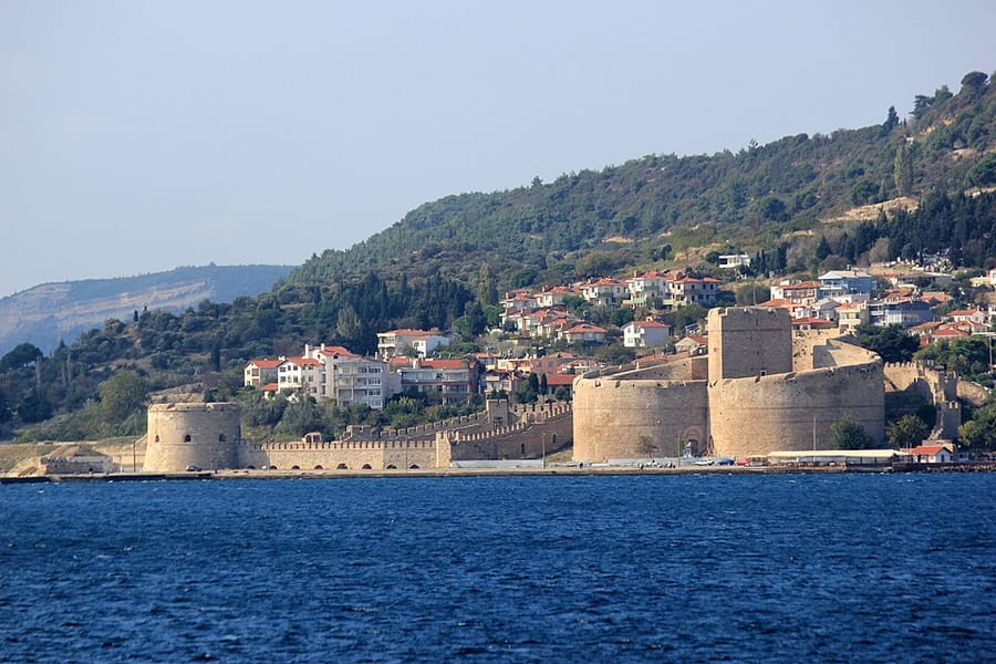
The fortress was built by Sultan Mehmed II (Fatih) on the European shore of the Dardanelles, opposite Kal'a-i Sultaniyye, to control passage through the strait. Its date is uncertain: Evliya Çelebi gives 1452, while the contemporary historian Tursun Bey writes that the two facing castles at the narrowest point of the strait were built after the conquest of Constantinople. According to Kritoboulos, Yakub Bey, governor of Gallipoli and commander of the fleet, was charged with building them in 1463, and the work was finished in 1464–65. An inscription of 1541 on a tower shows that the fortress was repaired and enlarged under Suleiman the Magnificent.
The fortress has two parts: a tall inner citadel shaped like a three-leaf clover, unparalleled in military architecture, and a lower wall around it. At the centre of the clover rises a triangular tower about 30 m high, which contained seven wooden floors. Süleyman's addition extended the wall southwards and ended it with a round tower 21 m in outer diameter. The fortress is 220 m long and 120 m wide. In 1659 Evliya Çelebi saw a residential quarter and a mosque, the Hünkar Camii, inside it. Some of its walls along the shore have collapsed.
The fortress in the sources
Tursun Bey writes that of the two facing fortresses built at the place called Eceovası, one was named Kilidü'l-bahr (Lock of the Sea) and the other Sultaniye, and that cannon were placed in them. In the early 16th century Piri Reis noted that ships leaving the Sea of Marmara obtained permission to pass from this fortress on the European shore, but that because the water was deep and the current strong, large ships could not anchor in front of it; he drew a map showing sketches of the two fortresses.
Evliya Çelebi writes that the fortress had granaries and an arsenal but no han, bath or market, and that cannon brought from the fortresses of Modon and Koron in the Morea were placed on the shore; according to him there were sixty-two guns on the shore and forty inside. A second inscription, dated 1893–94, is above the gate of the outer wall; a third, dated 1493, found on the ground by Ayverdi, may belong to a fountain.
The trefoil inner keep
The main entrance is on the sea side and is reached by ramps from both directions. Each lobe of the trefoil encloses a round courtyard, into which the loopholes of the central tower allow easy fire. Each face of the triangular central tower is about 20 m long and curved rather than flat; the trefoil main tower has been measured at up to 18 m high. On the landward side there was a ditch about 10 m wide with sloping walls, and the fortress is known to have had three gates, one on the sea side. The lead-covered wooden conical roofs of the towers disappeared from the 18th century onward.
Brick decoration can be seen on the walls of the inner keep, which shows that its unknown architect had an outstanding knowledge of geometry. The fortress was later reinforced with guns able to fire at water level. The first study of it was H. Högg's thesis, published as a book in 1932; Ismail Utkular's thesis was printed in 1953, and Ekrem Hakkı Ayverdi carried out a broader study and drew new survey plans.
Source: TDV Encyclopedia of Islam (TDV İslâm Ansiklopedisi), “KİLİTBAHİR KALESİ” (Semavi Eyice)
Related sultans
Cite as: Atlas of the Sultans, “Kilitbahir Castle · Ottoman monuments”, https://padisahlaratlasi.com/en/monuments/kilitbahir-castle/ (last updated 21 November 2026). Corrections · Image credits